


Wednesday, July 17th 2019, 1:58 pm - Locally heavy downpours have caused significant flooding in parts of southern Ontario

Summer revealed! Visit our Complete Guide to Summer 2019 for an in-depth look at the Summer Forecast, tips to plan for it and much more
WEATHER HIGHLIGHTS:
- Remnants of storm Barry create unsettled pattern with flood potential through Wednesday
- Heat and humidity last through the week across Ontario, many areas exceed the 30°C mark
- Heat wave set to end by Sunday with the passage of a strong cold front
- Stay up-to-date on the ALERTS in your area
FLOODING RAIN HITS SOUTHERN ONTARIO
The atmosphere is feeling very tropical-like across much of southern Ontario as a tropical airmass dumps heavy rain over parts of the region through the day Wednesday."We're watching the remnant moisture from storm Barry -- what was once Hurricane Barry -- which made landfall in the Gulf states last weekend as it tracks across southern Ontario," says Weather Network meteorologist Kelly Sonnenburg. "So that's really jam packing the atmosphere full of moisture."
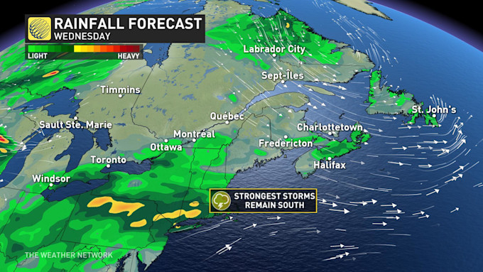
The heaviest rain began across southwestern sections of the province early Wednesday, prompting a special weather statement for up to 40 mm of rain for areas from Niagara to south Lake Huron. That statement expanded to the Greater Toronto Area ahead of the morning commute, warning of locally heavy rain.
According to radar estimates, 50+ mm had already fallen across parts of the region before the the lunch hour.
Flooding has been reported across the GTA with torrential downpours closing some major roadways in parts of the Toronto area. By 10 a.m., Kipling Avenue had been closed from Bethridge to Belfield roads as a result of the flooding and Rexdale Boulevard was also closed from Islington to Bergamot avenues. The Eastbound collector lanes to Islington Avenue on Highway 401 were also submerged in water.
Multiple vehicles were left inundated, with reports of some drivers forced to leave their cars completely stranded.
Multiple vehicles were left inundated, with reports of some drivers forced to leave their cars completely stranded.
THUNDERSTORM THREAT
While the heaviest rain is expected to wrap up gradually during the early afternoon hours, the risk for thunderstorms will continue through the day and have the potential to unleash more heavy rain and flash flooding in isolated areas.These storms are expected to be slow-moving and could even remain semi-stationary over the same areas, heightening a localized flood threat even further.
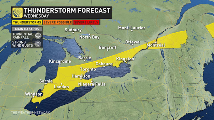
High pressure over northern Ontario will bring sunshine to the north and through cottage country on Wednesday as the northerly flow tries to push the boundary south.
This will also interact with a weak lake breeze along the north shore of Lake Ontario and possibly Lake Erie by mid-afternoon and will spark isolated showers and thunderstorms
.
Several sightings of funnel clouds were reported in the Barrie area in the early afternoon, and Environment Canada issued a weather advisory saying more funnel clouds may be possible.
"These types of funnel clouds are generated by weak rotation under rapidly growing clouds or weak thunderstorms. This weak rotation is normally not a danger near the ground. However, there is a chance that this rotation could intensify and become a weak landspout tornado," Environment Canada says.
WATCH BELOW: HERE IS WHAT YOU DO IF YOU ENCOUNTER FLASH FLOODING
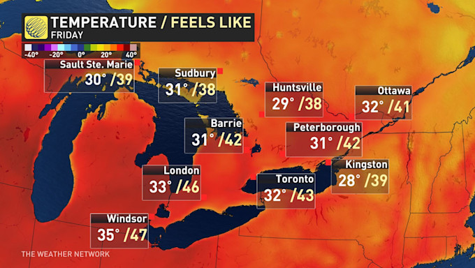
HUMIDITY PEAKS AT DANGEROUS LEVELS
"The heat will peak on Friday and Saturday with truly tropical humiditly. This will give us a dangerous humidex reaching the low to mid 40s," warns meteorologist Dr. Doug Gillham.Gillham adds that the overall pattern heading into the weekend will bring the threat for scattered strong to severe thunderstorms with more widespread rain and strong winds.

No comments:
Post a Comment